 Filter: Categories of Wisconsin Historical Images
Filter: FORMAT_DIMENSIONS of 25 x 21 inches
Filter: Categories of Wisconsin Historical Images
Filter: FORMAT_DIMENSIONS of 25 x 21 inches

| Date: | 1900 |
|---|---|
| Description: | Hydrographic map of Lake Mendota and it's adjacent topography. Prepared from surveys made by civil engineering students, University of Wisconsin, classes 1... |
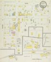
| Date: | 12 1899 |
|---|---|
| Description: | Sanborn map of Montfort, population 800. |
If you didn't find the material you searched for, our Library Reference Staff can help.
Call our reference desk at 608-264-6535 or email us at: